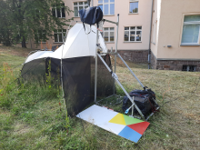
Students in geoecology, geoinformatics, geophysics and computational material science are currently creating a prototype for recording biodiversity indicators. The photographic AI-based solution approach provides large-scale information on local biodiversity, in contrast to manual counts that only reveal a small slice of biodiversity. The death of endangered insects for research purposes can also be avoided.

The reason for the research is the dramatic decline in species diversity as a result of climate change and extensive land use by humans. The systematic recording of existing insect populations represents an important basis for the urgently needed development of countermeasures. At the same time, this complex task requires interdisciplinary work. In the techno-ecological project module, the various disciplines such as geoecology, biology, computer science, measurement and sensor technology work together synergistically and explore interdisciplinary solutions for development, modeling and recording.
For the prototype, the participants combine two different measurement methods: a classic Malaise trap with camera attachment and a paint template with its own camera-based recording system. All technical elements were developed by the participants themselves and installed with the support of the Institute of Computer Science. On two measurement days, the participants produced 11388 images. In addition to the bristle leaf weevil or the meadow foam cicada, they were able to detect a total of 1472 insects from different families. Using an unsupervised learning approach - a machine learning method that enables classification without an annotated dataset - they analyze the insect population and prepare the data for a more detailed classification.
"In this respect, the student research project on insect occurrence at the representative study object TUBAF campus discusses both technical-methodological and geo-ecological issues and aims at a long-term implementation of the prototype," explains junior professor Maximilian Lau. "Other focal points include the challenges of site selection, classification of individual species and system configuration." The latter refers not only to the trap system as such, but equally to the complex acquisition system with camera, lighting, embedded computing system and image processing.
Interdisciplinary collaboration
The supervising team of professors from Faculties 1 (Mathematics and Computer Science), 3 (Geosciences, Geotechnical Engineering and Mining) and 4 (Mechanical, Process and Energy Engineering) underlines the interdisciplinary character of the module and steers students from the different disciplines toward the overall learning goal. "The decisive moment is always the first event," explains junior professor Christian Kupsch, who coordinated the event. "This is where it becomes apparent what competencies are available in the student team and what scope this gives rise to for the specific task at hand."
In the summer semester of 2023, a well-balanced group of students came together. In regular meetings, the participants from the various disciplines learned to coordinate successfully in an interdisciplinary team and overcame initial teething problems regarding interaction and coordination. Supported by the Saxony State Office for the Environment, Agriculture and Geology, they ended up developing their own concept for the AI-based recording of biodiversity on campus.
Junior professor Maximilian Lau rates the positive result of the complete development of a prototype as a good starting point and is already looking forward to the follow-up project in the summer semester of 2024 being able to build on it.