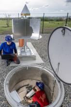
In mid-October, researchers from the TU Bergakademie Freiberg put a new geomonitoring station into operation on the slag heap of the "Reiche Zeche" research and training mine. In future, the high-tech measuring devices will provide local data for research - for monitoring ground movements, for highly accurate determination of inclinations and settlements for deformation analysis, for position determination of location and height, and as a connection point for shaft plumbing and orientation for underground surveys.

After more than a year of planning and application phase for the building permit to erect a geomonitoring station on the slag heap of the "Reiche Zeche" research and training mine, construction could begin on 23 August 2023. In the process, the Institute for Mine Surveying and Geodesy of the TU Bergakademie Freiberg (TUBAF) had to comply with monument protection, nature conservation, the UNESCO World Heritage Site "Montanregion Erzgebirge/Krusnohori" and other requirements before the construction site could be opened. In cooperation with the construction department of the TUBAF, the architect's office Büschel (design author), the Vogler Bauunternehmung GmbH (contractor shell construction), Mr. Dipl.-Bauing. Gerd Pfeifer (site manager) as well as the staff of the Institute for Mine Surveying and Geodesy of the TU BAF, the construction project was successfully completed on 29 Sept. 2023. With the electronic installation of the TU BAF and the commissioning of the corner reflector with GNSS station by the company ALLSAT from Hanover, the multi-sensor geomonitoring station for measurement data acquisition could be put into operation on 17 Oct. 2023.
The Institute for Mine Surveying and Geodesy at the TU Bergakademie Freiberg uses the multi-sensor geomonitoring station to monitor ground movements such as subsidence, inclinations, position and height differences on the slag heap of the "Reiche Zeche" research and training mine with high precision. The geomonitoring station combines four essential measuring instruments for high-precision determination of the movements of the earth's surface: - double corner reflector (ALLSAT) for satellite-based radar interferometry for ground motion monitoring, - a laser precision hose level (LSW) developed in cooperation with FPM Holding GmbH (Freiberger Präzisionsmechanik), TU Dresden, Electronic Renaissance Dresden and TU Bergakademie Freiberg for highly accurate determination of inclinations and settlements for deformation analysis, - an integrated GNSS station (Global Navigation Satellite System) for high-precision determination of position and height, and - a measuring column support with height bolt (levelling) for a gyro instrument as a connection point for shaft plumbing and orientation for underground surveys.
Corner reflectors in satellite-based radar interferometry
Corner reflectors are special arrangements of surfaces or structures that reflect electromagnetic radar waves back towards their source with maximum efficiency. They have the special property that they send radar beams back in the direction of the radar regardless of their angle of incidence and polarisation.
This makes them extremely valuable tools in radar interferometry, as they appear as particularly dominant backscatterers in radar images, such as those of the Copernicus Sentinel-1 satellite. Radar images are divided into ascending and descending orbit images with respect to their acquisition configuration. Ascending orbit images are acquired when the satellite is moving from south to north in its approximately polar orbit and thus has a west-to-east line of sight, as the measurement/viewing direction of these systems is always to the right (90° to the direction of flight). Recordings in the descending orbit therefore have an exactly opposite orientation. Therefore, the installation of a combined (double) corner reflector is necessary to evaluate both orbits and to derive precise vertical and horizontal (east-west direction) ground motions from their combination.
The importance of corner reflectors for the use of radar interferometry is manifold:
- Calibration and quality assurance: Corner reflectors serve as stable and well-defined radar targets that can be used in different phases of radar interferometry to ensure calibration and quality assurance of the measured data. They allow the performance of the radar system to be accurately characterised.
- Topographic reference: Since corner reflectors represent stable radar targets, they serve as known topographic reference points in satellite-based radar images. A precise calibration of these radar targets by means of GNSS or total station thus enables a precise georeferencing of the measured data and thus also the connection to known measurement networks, so that absolute changes can also be derived from the relative changes of the earth's surface.
The construction of the multi-sensor geomonitoring station could be realised with the kind support of the Dr. Erich Krüger Foundation. It is used for research and teaching in the field of obtaining reliable geodetic information in the context of ground motion monitoring. Furthermore, the measurement data can be used for the high-precision determination of the earth's surface movements in the ongoing research projects such as MONDIS (Krüger Foundation), CLEAR (BMBF joint project) for the Institute for Mine Surveying and Geodesy at the TU Bergakademie Freiberg.