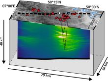
Researchers at TU Bergakademie Freiberg and KIT have re-evaluated old seismic data using modern imaging methods and localised potential magmatic areas beneath the Eifel region. The new seismic evaluation method, which has been developed at the Institute of Geophysics and Geoinformatics at TUBAF in recent years and has now been tested on this data, can also be used in other regions to investigate volcanic activity as well as to locate raw material deposits.
When you think of volcanic activity, you don't usually immediately think of Germany. But volcanoes were still erupting in the Eifel 11,000 years ago. The volcanic field has been dormant ever since. Researchers at TU Bergakademie Freiberg and the Karlsruhe Institute of Technology (KIT) have now analysed the earth's crust beneath the region using modern seismic imaging techniques. The detailed images show previously unknown structures that can be interpreted in connection with magmatic fluids and which presumably originate from the Earth's upper mantle. They have published their results in the scientific journal Geophysical Research Letters.
"Our analysis is based on data that is 35 years old. We can now extract and analyse much more detailed images of underground structures from the existing data sets, as the processing of seismic reflection data has greatly improved," says the first author of the study, Dario Eickhoff, who carried out the study as part of his Master's thesis at the Institute of Geophysics and Geoinformatics at TU Bergakademie Freiberg. "This allowed us to visualise previously identified structures at a higher resolution and map previously unknown features," says the TUBAF alumnus, who is currently working on his doctorate at Karlsruhe University.
The structures discovered at a depth of 10 to 30 kilometres resemble elevations or flat layers of magmatic rock that have been pushed between the existing rock. The features examined indicate that they could be pockets of magmatic melts, liquids or supercritical gases that have risen from the Earth's upper mantle to a depth of more than 50 kilometres into the Earth's crust. The supercritical gases could primarily be magmatic carbon dioxide, which occurs frequently in the Eifel and is practically liquid at depth due to the uplift pressure, says Eickhoff. "These potential magmatic areas could lead to lava eruptions in the region in the future if the magma gains enough buoyancy to rise to the surface." The researchers believe that further investigations using state-of-the-art geophysical methods are necessary to better assess the specific danger.
Potential of the new method for raw material exploration
The team at TU Bergakademie Freiberg is also applying the method for analysing the old data from the Eifel to other existing geophysical data. The potential of such old data for current issues is enormous, says Professor Stefan Buske, who supervised Dario Eickhoff's master's thesis: "For example, we have reprocessed data from 1986 from the Bushveld complex in South Africa and obtained high-resolution images that can be used to estimate the chances of exploring for mineral resources in this area much better than before." But such newly processed data also provides important insights for the Ore Mountains, emphasises Professor Stefan Buske. In his working group, many of the old seismic data sets from the Ore Mountains have now been reprocessed. The structures of the earth's crust and the upper mantle beneath the Ore Mountains mapped in this way provide a good basis for research into the formation of the Ore Mountains and its many mineral deposits.
