Geomatics for Mineral Resource Management
In order to continue to meet the global demand for mineral resources, it is necessary to drive forward their extraction in areas of the geosphere that are characterised by increased mining geological complexity and complex interaction with the environment and the social environment. Under these conditions, the primary objective remains to ensure maximum safety for the public and mining operations, to act in an ecologically and socially responsible manner and to utilise natural resources in the best possible way. The integration of all process steps in the extraction of natural resources into an "end-to-end" perspective, which enables transparent communication of sustainable process indicators between process steps and also between all project participants and interest groups, is an essential necessity for this. The basis for this is the use of state-of-the-art sensor technologies to collect georeferenced data and for data management, state-of-the-art methods for extracting and analysing information and integrating it into decision-making models, such as deposit models or models for predicting environmental impacts. This approach requires core competencies in the fields of surveying technology and sensor technology, data processing and geoinformatics as well as geomodelling, or "GEOMATICS" for short.
The aim of this M.Sc. degree programme in Geomatics for Mineral Resource Management is to provide students with the necessary skills to develop innovative geomonitoring concepts for case-specific solutions along the process chain of raw material exploration and extraction. Students are familiarised with research results from several large European research projects. The implemented interaction with several local industry partners enables students to participate in real projects, understand the needs of the industry and train themselves in entrepreneurial skills.
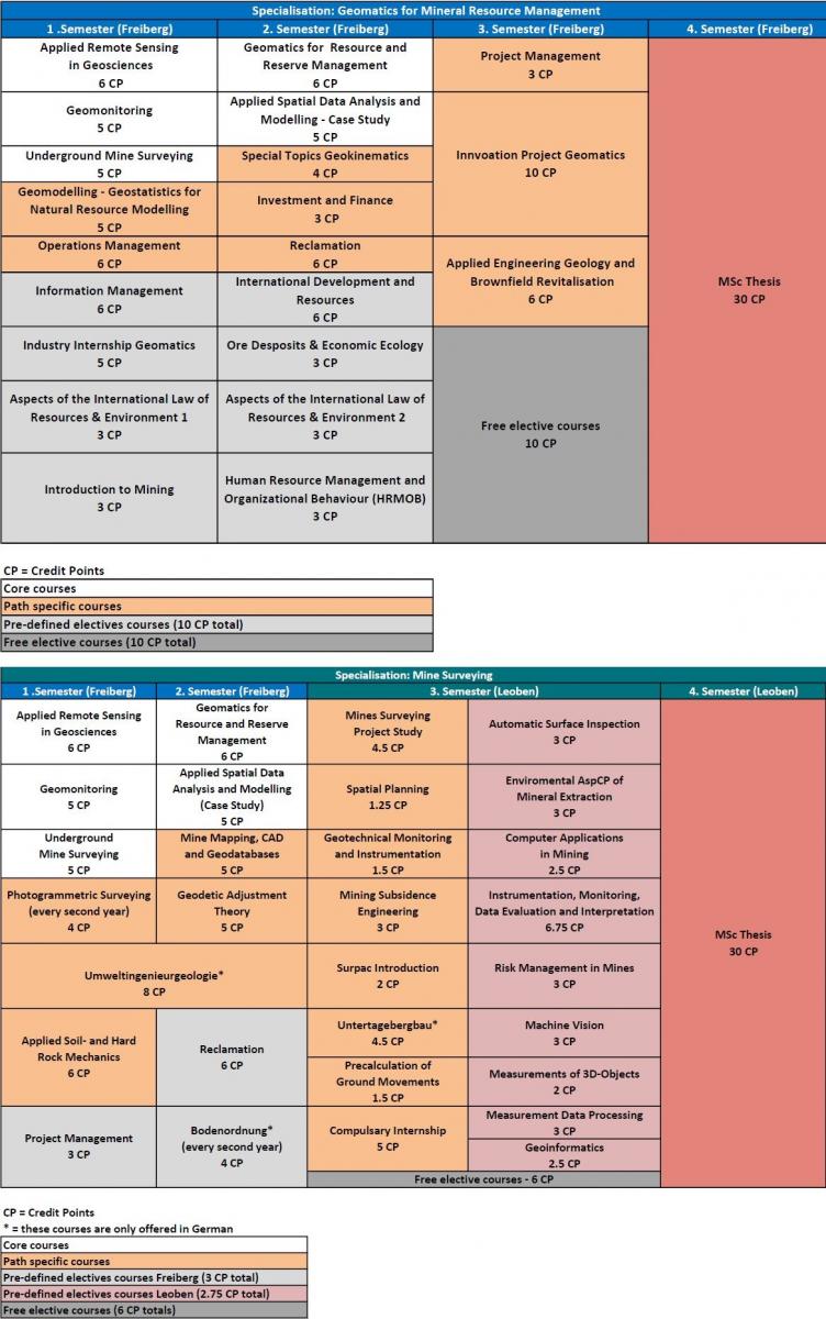
The degree programme enables students to study internationally. During the degree programme, students can choose to specialise in specialisation 1, Geomonitoring for Mineral Resource Management, or specialisation 2, International Mine Surveying. The latter leads to a joint degree with the University of Leoben. Double degrees with the technical universities in Lisbon, Portugal and Wrozlaw, Poland are also planned.
In future, graduates will be able to take on a leading role in the field of Geomatics for Mineral Resource Management.
Please note that this is an English-language Master's degree programme. Applications can be submitted online via the university portal and are possible from 1 January to 15 April.
Specialisations
Specialisation in deposit modelling and mine planning
This specialisation focuses on the processes of deposit modelling and mine planning. In addition to these subject-specific components, students are also taught about the financial, political, legal, economic and environmental aspects of a mining project in a variety of subjects.
Specialisation International Mine Surveying
This specialisation is carried out in cooperation with the University of Leoben and focuses on the acquisition, processing and analysis of measurement data relevant to mine surveying and other "big data" within a mining process. Students learn a wide range of measurement methods and how to use modern technologies such as machine vision in relation to mining.
- Faculty
-
Faculty of Geosciences, Geoengineering and Mining (Faculty 3)
- Degree
-
Master of Science (M. Sc.)
- Standard period of study
-
4 Semester
- Part-time possible
-
No
- Start of studies
-
Winter semester
- Admission requirement
-
- a first professionally qualifying university degree of at least six semesters at a university in the fields of mine surveying, geodesy, geoinformatics, geoengineering or applied geosciences
- a qualification assessment procedure in accordance with Annex 2
- proof of completion of the following or equivalent modules: Advanced Mathematics for Engineers 1 and 2, Introduction to Computer Science, Physics for Engineers, Data Analysis/Statistics and General Principles of Surveying and Instrumentation, Introduction to Geosciences
English proficiency
- TOEFL 90 points (internet-based test) or
- IELTS 7.0 or
- equivalent language test or
- German language skills at level B1
This does not apply to foreign applicants whose national language is English.
- Course language
-
English
- Raw materials management: e.g. in mine surveyors' offices of mining and exploration companies
- Geotechnology: e.g. in tunnelling in tunnelling, dam construction, remediation mining, utility companies
- Soft and hardware development
- Sales: e.g. in the field of geotechnics
- Public administration: e.g. mining and environmental authorities
Prerequisites for the degree programme
- A first professionally qualifying university degree of at least six semesters, for example a Bachelor's degree in mine surveying, geodesy, geoinformatics, geoengineering or applied geosciences
- Proof of completion of the following or equivalent modules: Advanced Mathematics for Engineers 1 and 2, Introduction to Computer Science, Physics for Engineers, Data Analysis/Statistics and General Principles of Surveying and Instrumentation, Introduction to Geosciences
- English language skills, which must be proven by a recognised language test such as the Test of English as a Foreign Language (TOEFL) with at least 90 points (internet-based test) or the International English Language Test System (IELTS) with a score of at least 7.0. Applicants whose national language is English are exempt from this requirement.
- German language skills proven by a recognised language test such as Goethe Zertifikat B1 or telc Deutsch B1 or at least 120 hours of German lessons at B1 level. For specialisation 2: Mine Surveying, the Goethe Zertifikat B2 or telc Deutsch B2 is recommended, as this specialisation contains German-language modules


