
Promotes here
The European Union
Project start: 2024
"Intelligente Untergrundstrukturen / Intelligent Geosystems: AI-Enhanced Geoengineering Tools for Decision Support in Energy Transition, Mitigation of Climate Change Effects and Geo-Risks in Former Mining Regions"
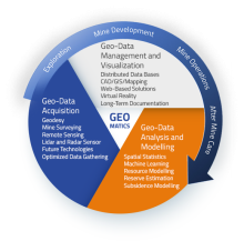
The transformation of still active lignite mining regions into ecologically and economically sustainable lake, forest, industrial, energy and recreational landscapes as well as dealing with underground old mining in the Ore Mountains are among the major societal challenges in Saxony. While the focus is currently very much on existing geohazards, post-mining landscapes also offer opportunities to mitigate the damaging consequences of extreme hydrological events and make landscapes more resilient to climate change. The need for solutions is high and will continue to increase. Implementation requires intelligent utilisation of existing and new underground structures. Intelligent underground spatial planning requires informed decisions that take into account all currently available and relevant data and previously generated knowledge and link them in a targeted manner. This in turn requires skills development in the future areas of environment, raw materials and digitalisation. The aim of the project is to train the necessary specialists in the fields of geoengineering and digitalisation.

HYDRO-LaWa
01.04.2021 - 31.03.2023
Funding code: KK5281201BA1
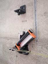
The objective of the "HYDRO-LaWa" project is to
develop an
innovative and intelligent hydrostatic precision laser tube scale, demonstrate its functionality under operating conditions in various
applications and prepare the commercialisation of the measuring system
. The innovation lies in the novel combination of the two
measurement tasks "settlement and inclination" in deformation monitoring, which can be determined with a
high measurement accuracy very precisely, continuously and over long periods of time due to the design
related robustness.
The project partners are FPM Holding GmbH (project coordinator) and TU Dresden (Chair of Engineering Geodesy).